
On Saturday, November 16, 2019, we drove here, there and over yon, from one end to the other of Washington State Route 525.
RCW 47.17.735
State route No. 525:
A state highway to be known as state route number 525 is established as follows:Beginning at a junction with state route number 5 in the vicinity south of Everett, thence northwesterly to the state ferry terminal at Mukilteo; also
From the junction with state route number 526 at Mukilteo, thence southerly to a junction with state route number 525; also
From the state ferry terminal at Mukilteo via the state ferry system northerly to the state ferry terminal at Clinton; also
From the state ferry terminal at Clinton, thence northwesterly to a junction with state route number 20 in the vicinity east of Keystone.

Highway 525 begins in Lynnwood here at the Swamp Creek Interchange (lovely!) with I-5 and I-405. Highway 525 was the last-built leg of this interchange, not open till the 1980s. Highway 525 is part of the Cascade Loop, which will take you from the mountains to the sea.
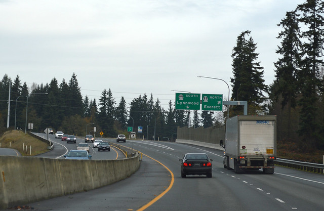
The first section of Highway 525 was widened from two lanes to a four-lane freeway in 2000. That project also included this interchange with SR 99.

Welcome to the Mukilteo Speedway! The "speedway" was around before the previous freeway section, which might go some way to explain how the section with a lower speed limit plus stop lights has that name. We are very near Paine Field (newly a commercial airport), but we can't see it from here, as we are slightly below it. Nevertheless, at the west edge of the airport, we come to the junction with SR 525 Spur, which is a shortcut to SR 526 and the north side of Paine Field.

We begin our curving descent to Mukilteo's town center, but shortly arrive at this unassuming junction with SR 526.

Down down down we go, all the way to the Mukilteo ferry dock. Mukilteo is longer than Isabelle remembers. The dock is straight ahead and the ticket booth is to the right. Where should we go?
Turn around! Back to the spur! Drive in circles!

Curiously, Highway 525 Spur per code goes southward, but WSDOT tracks the mileposts going northward. I'm following the code description, so we thus resume at this junction with SR 526, right at the back entrance to Paine Field and the front entrance of the Future of Flight museum.

A short mile down the boulevard later, we're back at the mainline of SR 525. Spur complete.
After a coffee break, we resume the mainline of Highway 525, down at the ferry dock again.

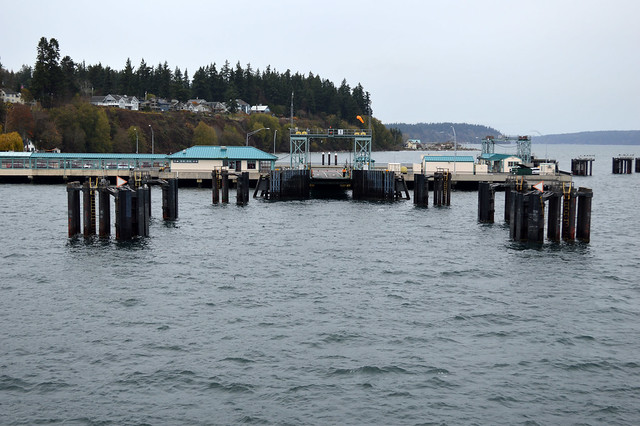
Here we are again at the Mukilteo ferry dock, but this time we're boarding the ferry for Whidbey Island. Anchors aweigh!

On board the MV Suquamish, we push off from Mukilteo onto the calm waters of Possession Sound. Halfway across, I snap this picture. Cool, gray, not windy and mostly dry. Standard fare for a ferry ride around these parts. It's a quick crossing, only 20 minutes. The jigsaw puzzles aboard must take many sailings to complete. Isabelle stayed in the car to read.
The forested hill of Whidbey Island looms large as we approach the Clinton ferry dock. Everyone hurries for their cars, although there's plenty of time.

Once back on land and behind the wheel, we drive up a little canyon onto the plateau of south Whidbey. Rain comes down as we traverse the forest with scattered homes and small farms. Free land! No, Freeland. As I drive, I get only a few brief glimpses of water through the trees. Are you sure this is an island? At the skinny section near Holmes Harbor, we cross from south Whidbey to central Whidbey. The addresses on the highway are by milepost (eg 19500 would be halfway between mileposts 19 and 20). Isabelle falls asleep. The miles roll by. The junction with SR 20 comes up quick, so I pull off the road and take the photo myself. Isabelle stirs. Time to explore Coupeville.
Highway 525 originally continued the length of Whidbey Island, across the Deception Pass bridge, and back toward Mount Vernon to end at a junction with SR 536. In 1973, however, SR 20 was laid across the existing highways and Highway 525 was shortened to end near the Keystone/Coupeville ferry dock.
What more can I say? Whidbey Island makes a lovely day trip.


No comments:
Post a Comment